Colorado
Ghost Towns &
Mining Camps
Tours
1.
Columbia City
2.
Beaver City,
Vicksburg,
Rockdale/Silverdale,
Winfield
2a)Tasmania Mine
2b)Swiss Boy Mine
2c)Fortune Mine
2d)Banker Mine
2e)Hamilton
2f)Clohsey Lake
3.
Latchaw Mine
4.
St. Elmo
4a)Romley/Hancock
4b)Alpine Tunnel
4c)Mary Murphy
Mine
5.
Midland, Fourmile,
Free Gold Hill
Tour 2e: Hamilton
| To
View Info On Other Tours In This Area Click On The Letters In The Close-Up Map Below Or Go To The Over-All Clear Creek Area Map 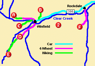
|
Destination: Hamilton
General Location: 2 miles south of the Banker Mine and approximately 3.5 miles southwest of Winfield
How To Get There: Take the left fork out of Winfield (County Road 390) and take the 4 wheel drive road 2.2 miles to the USFS closure gate at the S. Fork Clear Creek trailhead. This gate is 1/2 mile past the Banker Mine.
Difficulty: The trail to Hamilton is 1.5 miles long, extremely easy with a 200 foot elevation gain, and loaded with spectacular views. Please stay on the trail as rare plants have a tenuous existence in the area. There is not much left of Hamilton, so keep your eyes open to your right, but the hike is the worth the effort.
Private Property & Responsible Recreation: Venturing off of public roads and lands onto private land is trespassing. The surrounding mountains have miles of underground tunnels and shafts. The area is dangerous and a once safe and stable area can suddenly collapse. The buildings also are in various state of decay and are also unsafe. Obey any posted signs, travel & recreate responsibly, and always tread lightly.
History of Hamilton: A number of prospecting "holes" were punched in the ground in this area, but the Hamilton Mining and Tunnel Company operated the most successfully here until 1905. Hamilton was primarily a mining camp composed of only 4-5 buildings, and remains as one of the most remote mining operations in the Clear Creek Canon area, although by following the Apostle Basin Trail further on, sparse remnants remain of the Wallace Mine operation.
Area Photos: Click To Zoom.
[Main Tour Map]
